Tampilkan postingan dengan label CO. Tampilkan semua postingan

Fires threaten Santa Barbara


New mandatory evacuation orders have been issued for the areas of Montecito, Summerland and some parts of Santa Barbara city, emergency officials said.


Above graph shows carbon monoxide (CO) and carbon dioxide (CO₂) levels from December 5 - 20, 2017, while the map below shows the location of the measurements (and forecasts).


The graph shows levels at one location and for one time of day (00:00 UTC for CO, respectively 01:30 UTC for CO₂). On December 11, 2017, at this location, but at 22:30 UTC, CO levels were 55639 ppb and CO₂ levels were 898 ppm, as illustrated the combination image below (left panel).

The right panel of the image below shows that CO₂ levels were as high as 922 ppm on December 7, 2017, at 01:30 UTC at a slightly different location. No CO₂ measurements were available for December 9 and 10, 2017, but given that levels of CO₂ and CO typically go up and down hand in hand, CO₂ may have peaked at well over 1000 ppm on December 9, 2017, possibly exceeding the 1229 ppm CO₂ measured in Montana on July 22, 2017.


Such fires look set to cause increasing amounts of emissions, speeding up warming of the atmosphere. These fires were fueled by extremely dry, hot and strong winds lasting for many days. Global warming is behind all these conditions. Not only does more heat translate into higher temperatures and stronger winds, the decreasing temperature difference between the Arctic and the Equator is also increasing the intensity and duration of more extreme weather events such as storms and droughts. A record 129 million trees on 8.9 million acres have died in California due to drought and bark beetles infestation.


“For the first time in history, on December 7th, the Cal Fire elevated the fire threat to purple for San Diego County, warning that the weather conditions presented an extreme risk of fire for San Diego,” California Governor Jerry Brown wrote in a request for federal emergency assistance. “Fire officials predict extreme winds of up to 80 miles per hour, equal to the wind speed of a category one hurricane.”


The following is an extract from the California Scoping Plan 2017:
In California, as in the rest of the world, climate change is contributing to an escalation of serious problems, including raging wildfires, coastal erosion, disruption of water supply, threats to agriculture, spread of insect-borne diseases, and continuing health threats from air pollution. The drought that plagued California for years devastated the state’s agricultural and rural communities, leaving some of them with no drinking water at all. In 2015 alone, the drought cost agriculture in the Central Valley an estimated $2.7 billion, and more than 20,000 jobs. Last winter, the drought was broken by record-breaking rains, which led to flooding that tore through freeways, threatened rural communities, and isolated coastal areas. This year, California experienced the deadliest wildfires in its history. Climate change is making events like these more frequent, more catastrophic and more costly.

The situation is dire and calls for comprehensive and effective action as described at the Climate Plan.


Links

• Climate Plan
https://arctic-news.blogspot.com/p/climateplan.html

• Wildfires 
https://arctic-news.blogspot.com/2017/07/wildfires.html

• Extreme weather is upon us 
https://arctic-news.blogspot.com/2017/09/extreme-weather-is-upon-us.html

• 10°C or 18°F warmer by 2021?
https://arctic-news.blogspot.com/2017/04/10c-or-18f-warmer-by-2021.html

• Abrupt Warming - How Much And How Fast?
https://arctic-news.blogspot.com/2017/05/abrupt-warming-how-much-and-how-fast.html

• Accelerating growth in CO₂ levels in the atmosphere
https://arctic-news.blogspot.com/2017/02/accelerating-growth-in-co2-levels-in-the-atmosphere.html

• Feedbacks
https://arctic-news.blogspot.com/p/feedbacks.html

• Warning of mass extinction of species, including humans, within one decade
https://arctic-news.blogspot.com/2017/02/warning-of-mass-extinction-of-species-including-humans-within-one-decade.html

• Turning forest waste into biochar
https://arctic-news.blogspot.com/2013/01/turning-forest-waste-into-biochar.html


Wildfires

Levels of carbon dioxide (CO2) in the atmosphere are accelerating, even though emissions from fossil fuel burning have remained virtually the same over the past few years.

One of the reason behind this is accelerating emissions from wildfires as temperatures are rising.

Wildfires in Nevada caused CO2 to reach levels as high as 742 ppm on July 12, 2017 (green circle image on the right).

Global warming is greatly increasing the chance for what was previously seen as an extreme weather event to occur, such as a combination of droughts and storms. Heat waves and droughts can cause much vegetation to be in a bad condition, while high temperatures can come with strong winds, storms and lightning.

Wildfires cause a range of emissions, including CO2, soot, methane and carbon monoxide (CO). In Nevada, CO levels were as high as 30.43 ppm (green circle image right).


Above satellite image below shows the smoke plumes and the charred area. The google maps image below further shows where the fires were burning.


At the moment, wildfires are hitting many places around the world.

Wildfires caused carbon dioxide to reach levels as high as 746 ppm in Kazakhstan on July 11, 2017 (green circle on image on the right).

Carbon monoxide levels in the area were as high as 20.96 ppm on July 10, 2017.

The satellite image shows wildfires in Kazakhstan on July 9, 2017.


The satellite images show wildfires in Kazakhstan on July 11, 2017.


On July 16, 2017, CO₂ reached levels as high as 830 ppm in North America at the location marked by the green circle on the image below. Note that fires are burning at multiple locations.


The image below shows the location (red marker) where the fires burned in Canada.


That same day, July 16, 2017, CO₂ reached levels as high as 873 ppm in Mongolia, as shown by the image on the right.

The image also shows further fires burning in Siberia.

Carbon monoxide levels were as high as 37.19 ppm where the fires burned in Mongolia on July 16, 2017, as shown by the image below.


The image below shows the location (red marker) where the fires burned in Mongolia. The image also shows Lake Baikal across the border with Russia.


On July 22, 2017, CO₂ reached levels as high as 1229 ppm in Montana, while CO levels at the time were as high as 56.38 ppm at that location (green circle on image below).


The satellite image below shows the situation in Montana on the next day, July 23, 2017. See also the
NASA post Grassland Fires Tear Through Montana.


Furthermore, on July 23, 2017, CO₂ reached levels as high as 884 ppm at another (nearby) location in Montana (green circle on image below).


Meanwhile, temperatures keep rising. Surface temperature as high as 53.1°C or 127.5°F were forecast in Iran for July 11, 2017, at the location marked by the green circle on the image below.


At 1000 mb (image below), temperatures in Iran were forecast to be slightly lower, i.e. as high as 51.9°C or 125.3°F at the location marked by the at green circle, but note the difference in color, especially over Greenland, the Himalayas and the Tibetan Plateau.


The situation is dire and calls for comprehensive and effective action as described at the Climate Plan.

Aerosols

Some aerosols, particularly sulfur dioxide, have a cooling effect, making that they partly mask the warming effect of other emissions by people. The IPCC AR4 image below shows that the direct and cloud albedo effect of aerosols equals a radiative forcing of as much as -2.7 W/m². In other words, if this masking effect were to fall away, warming would increase by as much as 2.7 W/m², according to IPCC AR4 figures.
Anthropogenic aerosols are also suppressing the Pacific Decadal Oscillation, making that less heat gets transferred from oceans to the atmosphere. Recent research concludes that future reduction of anthropogenic aerosol emissions, particularly from China, would promote positive Pacific Decadal Oscillation, thus further speeding up warming over the coming years.

Dimethyl sulphide emissions from oceans constitute the largest natural source of atmospheric sulphur, and such emissions can decrease with ongoing ocean acidification and climate change. This could particularly impact specific regions such as Antarctica, speeding up warming and loss of sea ice there, as discussed at this paper.

The net warming effect of open biomass burning was estimated in a 2014 study by Mark Jacobson to amount to 0.4 W/m² of radiative forcing. Imagine a scenario in which many people stopped burning fossil fuels for heating, cooking and energy. That would be great, but if many of them instead switched to burning biomass in woodburners and open fires, while wildfires increased strongly, the net warming from associated aerosols would increase dramatically.

A recent paper by James Hansen uses equilibrium fast-feedback climate sensitivity of ¾°C per W/m², while another recent paper suggest that the temperature rise per W/m² could be even stronger.

A high-end increase in net radiative forcing combined with a strong temperature rise per W/m² could cause a temperature rise as a result of changes in aerosols of as much as 2.5°C in a matter of years, as suggested in earlier posts such as this one.


Links

• Climate Plan
https://arctic-news.blogspot.com/p/climateplan.html

• 10°C or 18°F warmer by 2021?
https://arctic-news.blogspot.com/2017/04/10c-or-18f-warmer-by-2021.html

• Abrupt Warming - How Much And How Fast?
https://arctic-news.blogspot.com/2017/05/abrupt-warming-how-much-and-how-fast.html

• Accelerating growth in CO₂ levels in the atmosphere
https://arctic-news.blogspot.com/2017/02/accelerating-growth-in-co2-levels-in-the-atmosphere.html

• Feedbacks
https://arctic-news.blogspot.com/p/feedbacks.html

• Warning of mass extinction of species, including humans, within one decade
https://arctic-news.blogspot.com/2017/02/warning-of-mass-extinction-of-species-including-humans-within-one-decade.html

• Turning forest waste into biochar
https://arctic-news.blogspot.com/2013/01/turning-forest-waste-into-biochar.html


Earlier posts on Wildfires

• Wildfires in Russia's Far East
https://arctic-news.blogspot.com/2016/08/wildfires-in-russias-far-east.html

• Wildfire Danger Increasing
https://arctic-news.blogspot.com/2016/05/wildfire-danger-increasing.html

• Smoke Blankets North America
https://arctic-news.blogspot.com/2014/07/smoke-blankets-north-america.html

• More on Wildfires
https://arctic-news.blogspot.com/2013/08/more-on-wildfires.html

• Wildfires even more damaging
https://arctic-news.blogspot.com/2013/07/wildfires-even-more-damaging.html

• Wildfires in Canada affect the Arctic
https://arctic-news.blogspot.com/2013/07/wildfires-in-canada-affect-the-arctic.html

• The Threat of Wildfires in the North
https://arctic-news.blogspot.com/2013/06/the-threat-of-wildfires-in-the-north.html

• Russia: 74 million acres burned through August 2012
https://arctic-news.blogspot.com/2012/09/russia-74-million-acres-burned-through-august-2012.html

• Earth on Fire
https://arctic-news.blogspot.com/2012/06/earth-on-fire.html

• Fires are raging again across Russia
https://arctic-news.blogspot.com/2012/06/fires-are-raging-again-across-russia.html


Further reading on wildfires and aerosols

• NASA: Grassland Fires Tear Through Montana
https://earthobservatory.nasa.gov/NaturalHazards/view.php?id=90622

• 2016 fire risk for South America
http://www.ess.uci.edu/~amazonfirerisk/ForecastWeb/SAMFSS2016.html

• Global Fire Data - 2015 Indonesian fires
http://www.globalfiredata.org/updates.html#2015_indonesia

• Indonesia’s Fire Outbreaks Producing More Daily Emissions than Entire US Economy (2015)
http://www.wri.org/blog/2015/10/indonesia%E2%80%99s-fire-outbreaks-producing-more-daily-emissions-entire-us-economy

• Indonesia’s 2015 fires killed 100,000 people, study finds
http://www.climatechangenews.com/2016/09/19/indonesias-2015-fires-killed-100000-people-study-finds

• Smoke from 2015 Indonesian fires may have caused 100,000 premature deaths
https://www.seas.harvard.edu/news/2016/09/smoke-from-2015-indonesian-fires-may-have-caused-100000-premature-deaths

• Impact of anthropogenic climate change on wildfire across western US forests, by Abatzoglou et al.
http://www.pnas.org/content/113/42/11770.abstract

• The Mean and Turbulent Properties of A Wildfire Convective Plume, by Lareau et al.
http://journals.ametsoc.org/doi/10.1175/JAMC-D-16-0384.1

• Airborne measurements of western U.S. wildfire emissions: Comparison with prescribed burning and air quality implications, by Liu et al.
http://onlinelibrary.wiley.com/doi/10.1002/2016JD026315/abstract

• Hemispheric climate shifts driven byanthropogenic aerosol–cloud interactions, by Chung et al.
http://www.nature.com/ngeo/journal/vaop/ncurrent/full/ngeo2988.html

• Effects of biomass burning on climate, accounting for heat and moisture fluxes, black and brown carbon, and cloud absorption effects, by Mark Z. Jacobson
http://onlinelibrary.wiley.com/doi/10.1002/2014JD021861/abstract

• Amplification of global warming through pH-dependence of DMS-production simulated with a fully coupled Earth system model, by Jörg Schwinger et al.
https://www.biogeosciences-discuss.net/bg-2017-33

• Role of volcanic and anthropogenic aerosols in the recent global surface warming slowdown, by Doug M. Smith et al.
http://www.nature.com/nclimate/journal/v6/n10/full/nclimate3058.html

• Slow climate mode reconciles historical and model-based estimates of climate sensitivity, by Proistosescu et al.
http://advances.sciencemag.org/content/3/7/e1602821.full

• Young People’s Burden: Requirement of Negative CO2 Emissions, by James Hansen
http://csas.ei.columbia.edu/2017/07/18/young-peoples-burden-requirement-of-negative-co2-emissions


10°C or 18°F warmer by 2021?

Skyrocketing emissions

On April 21, 2017, at 15:00 UTC, it was as hot as 46.6°C/115.8°F in Guinea, in West-Africa (at the location marked by the green spot on the map below).


That same time and day, a little bit to the south, at a spot in Sierra Leona, a level of carbon monoxide (CO) of 15.28 parts per million (ppm) was recorded, while the temperature there was 40.6°C or 105.1°F. Earlier that day (at 13:30 UTC), levels of carbon dioxide (CO₂) of 569 ppm and of sulfur dioxide (SO₂) of 149.97 µg/m³ were recorded at that same spot, shown on the bottom left corner of the image below (red marker).


These high emissions carry the signature of wildfires, illustrating the threat of what can occur as temperatures keep rising. Further emissions that come with wildfires are black carbon and methane.


Above image shows methane levels on April 22, 2017, AM, at an altitude corresponding to 218 mb. Methane at this altitude is as high as 2402 ppb (magenta indicates levels of 1950 ppb and higher) and while the image doesn't specify the location of this peak, it looks related to the magenta-colored area over West Africa and this looks related to the wildfires discussed above. This wasn't even the highest level recorded that day. While at lower altitudes even higher methane levels were recorded that morning (as high as 2505 ppb), above image illustrates the contribution wildfires can make to methane growth at higher altitudes.


The table below shows the altitude equivalents in feet (ft), meter (m) and millibar (mb).
57,016 ft44,690 ft36,850 ft30,570 ft25,544 ft19,820 ft14,385 ft 8,368 ft1,916 ft
17,378 m13,621 m11,232 m 9,318 m 7,786 m 6,041 m 4,384 m 2,551 m 584 m
 74 mb 147 mb 218 mb 293 mb 367 mb 469 mb 586 mb 742 mb 945 mb


Above image compares mean methane levels on the morning of April 22 between the years 2013 to 2017, confirming that methane levels are rising most strongly at higher altitudes, say between 6 to 17 km (which is where the Troposphere ends at the Equator), as compared to altitudes closer to sea level. This was discussed in earlier posts such as this one.

On April 26, 2017, CO₂ levels at Mauna Loa, Hawaii spiked at 412.63 ppm.


As the image below shows, some hourly CO₂ averages for that day were well above 413 ppm.


These high CO₂ levels were likely caused by wildfires, particularly in Siberia.

CO₂ readings on April 26, 2017, 22:30 UTC
As said, besides emissions of CO₂, wildfires cause a lot of additional emissions, as illustrated by the images below.

As above image shows, methane levels as high as 2683 ppb were recorded on April 27, 2017. While the image doesn't specify where these high levels occurred, there are a lot of magenta-colored areas over Siberia, indicating levels over 1950 ppb. The image below shows carbon monoxide levels as high as 5.12 ppm near Lake Baikal on April 27, 2017.


As the image below shows, temperatures on April 28, 2017, were as high as 26.5°C or 79.6°F near Lake Baikal.


The satellite images below shows some of the wildfires. The images also show ice (in the left panel) over Lake Baikal on April 25, 2017, as well as over much of the Angara River that drains Lake Baikal. On April 28, 2017, much of that ice had melted (right panel).

[ click on images to enlarge ]
Warming oceans

Oceans are hit by high temperatures as well. The image below shows sea surface temperature anomalies (from 1981-2011) on April 21, 2017, at selected locations.


Accelerating temperature rises

The image below illustrates the danger of accelerating temperature rises.


Above image uses trendlines based on data dating back to 1880, which becomes less appropriate as feedbacks start to kick in that accelerate such temperature rises. Indeed, temperatures could rise even faster, due to feedbacks including the following ones:

Less sunlight getting reflected back into space

As illustrated by the image below, more ocean heat results in less sea ice. This makes that less sunlight gets reflected back into space and instead gets absorbed by the oceans.

[ Graph by Wipneus ]

More ocean heat escaping from the Arctic Ocean into the atmosphere

As discussed before, as less heat is mixed down to deeper layers of oceans, more heat accumulates at or just below the surface. Stronger storms, in combination with the presence of a cold freshwater lid on top of the North Atlantic, increase the possibility that more of this ocean heat gets pushed into the Arctic Ocean, resulting in sea ice loss, which in turn makes that more heat can escape from the Arctic Ocean to the atmosphere, while more clouds over the Arctic Ocean make that less heat can get radiated out into space. As the temperature difference between the Arctic Ocean and the Equator decreases, changes are occurring to the Northern Polar Jet Stream that further speed up warming of the Arctic.

More heat remaining in atmosphere due to less ocean mixing

As also discussed before, warmer water tends to form a layer at the surface that does not mix well with the water below. This stratification reduces the capability of oceans to take up heat and CO₂ from the atmosphere. Less take-up by oceans of CO₂ will result in higher CO₂ levels in the atmosphere, further speeding up global warming. Additionally, 93.4% of global warming currently goes into oceans. The more heat will remain in the atmosphere, the faster the temperature of the atmosphere will rise. As temperatures rise, more wildfires will erupt, adding further emissions, while heat-induced melting of permafrost will also cause more greenhouse gases to enter the atmosphere.

More seafloor methane entering the atmosphere

The prospect of more heat getting pushed from the Atlantic Ocean into the Arctic Ocean also comes with the danger of destabilization of methane hydrates at the seafloor of the Arctic Ocean. Importantly, large parts of the Arctic Ocean are very shallow, making it easy for arrival of more ocean heat to warm up these seas and for heat to destabilize sediments at the seafloor that can contain huge amounts of methane, resulting in eruptions of methane from the seafloor, with much the methane entering the atmosphere without getting decomposed by microbes in the water, since many seas are only shallow, as discussed in earlier posts such as this one.

These feedbacks are depicted in the yellow boxes on above diagram on the right.

How fast could temperatures rise?

When taking into account the many elements that are contributing to warming, a potential warming of 10°C (18°F) could take place, leading to rapid mass extinction of many species, including humans.
[ Graph from: Which Trend is Best? ]
So, how fast could such warming take place? As above image illustrates, it could happen as fast as within the next four years time.

The situation is dire and calls for comprehensive and effective action, as described at the Climate Plan.


Links

• Climate Plan
https://arctic-news.blogspot.com/p/climateplan.html

• Extinction
https://arctic-news.blogspot.com/p/extinction.html

• How much warming have humans caused?
https://arctic-news.blogspot.com/2016/05/how-much-warming-have-humans-caused.html

• Accelerating growth in CO₂ levels in the atmosphere
https://arctic-news.blogspot.com/2017/02/accelerating-growth-in-co2-levels-in-the-atmosphere.html

• Arctic Sea Ice Getting Terribly Thin


Wildfires in Russia's Far East

Wildfires can add huge amounts of carbon dioxide (CO2), carbon monoxide (CO), methane (CH4), nitrous oxide (N2O) and black carbon (BC or soot) into the atmosphere.

While CO and soot are not included as greenhouse gases by the IPCC, they can have strong warming impact. CO acts as a scavanger of hydroxyl, thus extending the lifetime of methane. BC results from biomass burning, which a study by Mark Jacobson found to cause 20 year global warming of ~0.4 K. Moreover, BC has a darkening effect when settling on snow and ice, making that less sunlight gets reflected back into space, which accelerates warming. This hits the Arctic particularly hard during the Northern Summer, given the high insolation at high latitudes at that time of year.

The image below shows fires around the globe on August 12, 2016.


Visible in the top right corner of above image are wildfires in Russia's Far East. The image below zooms in on these wildfires.


The image below shows carbon dioxide levels as high as 713 ppm and carbon monoxide levels as high as 32,757 ppb on August 12, 2016, at the location marked by the green circle, i.e. the location of the wildfires in Russia's Far East.


As said, wildfires can also emit huge amounts of methane. The image below shows methane levels as high as 2230 ppb at 766 mb.


The magenta-colored areas on above image and the image below indicate that these high methane levels are caused by these wildfires in Russia's Far East. The image below shows methane levels as high as 2517 ppb at 586 mb.


Methane levels as high as 2533 ppb were recorded that day (at 469 mb), compared to a mean global peak of 1857 ppb that day.

Analysis by Global Fire Data found that the 2015 Indonesian fires produced more CO2e (i.e. CO2 equivalent of, in this case, CO2, CH4 and N2O) than the 2013 CO2 emissions from fossil fuel by nations such as Japan and Germany. On 26 days in August and September 2015, emissions from Indonesian fires exceeded the average daily emissions from all U.S. economic activity, as shown by the WRI image below.

A recent study calculated that Indonesia’s 2015 fires killed 100,000 people.

Methane emissions from wildfires can sometimes be broken down relatively quickly, especially in the tropics, due to the high levels of hydroxyl in the atmosphere there. Conversily, methane from wildfires at higher latitudes can persist much longer and will have strong warming impact, especially at higher latitudes.

Similarly, CO2 emissions from wildfires in the tropics can sometimes be partly compensated for by regrowth of vegetation after the fires. However, regrowth can be minimal in times of drought, when forests are burned to make way for other land uses or when peat is burned, and especially at higher latitudes where the growth season is short and weather conditions can be harsh. Carbon in peat lands was built up over thousands of years and even years of regrowth cannot compensate for this loss.

A recent study concludes that there is strong correlation between fire risk for South America and high sea surface temperatures in the Pacific Ocean and the Atlantic Ocean. This makes the current situation very threatening. As the image below shows, sea surface temperature anomalies were very high on August 12, 2016.

Sea surface temperature and anomaly. Anomalies from +1 to +2 degrees C are red, above that they turn yellow and white
Above image also shows that on August 12, 2016, sea surface temperatures near Svalbard (at the location marked by the green circle) were as high as 18.9°C or 65.9°F, an anomaly of 13.6°C or 24.4°F. These high temperatures threaten to melt away the Arctic's snow and ice cover, resulting in albedo changes that accelerate warming, particularly in the Arctic. Warming of the Arctic Ocean further comes with the danger that methane hydrates at its seafloor will destabilize and make that huge amounts of methane will enter the atmosphere.

The situation is dire and calls for comprehensive and effective action, as described in the Climate Plan.


Links

 Effects of biomass burning on climate, accounting for heat and moisture fluxes, black and brown carbon, and cloud absorption effects, by Mark Z. Jacobson (2014)
http://onlinelibrary.wiley.com/doi/10.1002/2014JD021861/abstract

 2016 fire risk for South America
http://www.ess.uci.edu/~amazonfirerisk/ForecastWeb/SAMFSS2016.html

 Global Fire Data - 2015 Indonesian fires
http://www.globalfiredata.org/updates.html#2015_indonesia

 Indonesia’s Fire Outbreaks Producing More Daily Emissions than Entire US Economy (2015)
http://www.wri.org/blog/2015/10/indonesia%E2%80%99s-fire-outbreaks-producing-more-daily-emissions-entire-us-economy

 Indonesia’s 2015 fires killed 100,000 people, study finds
http://www.climatechangenews.com/2016/09/19/indonesias-2015-fires-killed-100000-people-study-finds

 Smoke from 2015 Indonesian fires may have caused 100,000 premature deaths
https://www.seas.harvard.edu/news/2016/09/smoke-from-2015-indonesian-fires-may-have-caused-100000-premature-deaths

 High Temperatures in the Arctic
http://arctic-news.blogspot.com/2015/06/high-temperatures-in-the-arctic.html


Wildfire Danger Increasing

Wildfires are starting to break out in British Columbia, Canada. The wildfire on the image below started on May 1, 2016 (hat tip to Hubert Bułgajewski‎).


The coordinates of the wildfire are in the bottom left corner of above map. They show a location where, on May 3, 2016, it was 26.0°C (or 78.8°F). At a nearby location, it was 27.6°C (or 81.8°F) on May 3, 2016. Both locations are indicated on the map on the right.

These locations are on the path followed by the Mackenzie River, which ends up in the Arctic Ocean. Wildfires aggravate heat waves as they blacken the soil with soot. As the Mackenzie River heats up, it will bring warmer water into the Arctic Ocean where this will speed up melting of the sea ice.

Moreover, winds can carry soot high up into the Arctic, where it can settle on the sea ice and darken the surface, which will make that more sunlight gets absorbed, rather than reflected back into space as before.

The danger of wildfires increases as temperatures rise. The image on the right show that temperatures in this area on May 3, 2016 (00:00 UTC) were at the top end of the scale, i.e. 20°C or 36°F warmer than 1979-2000 temperatures.

Extreme weather is becoming increasingly common, as changes are taking place to the jet stream. As the Arctic warms up more rapidly than the rest of the world, the temperature difference between the Equator and the North Pole decreases, which in turn weakens the speed at which the north polar jet stream circumnavigates the globe.

This is illustrated by the wavy patterns of the jet stream in the image on the right, showing the situation on May 3, 2016 (00:00 UTC), with a loop bringing warm air high up into North America and into the Arctic.

In conclusion, warm air reaching high latitudes is causing the sea ice to melt in a number of ways:
  • Warm air makes the ice melt directly. 
  • Warmer water in rivers warms up the Arctic Ocean. 
  • Wildfires blacken land and sea ice, causing more sunlight to be absorbed, rather than reflected back into space as before.  
[ click on images to enlarge ]
The situation doesn't appear to be improving soon, as illustrated by the image on the right. Following the record high temperatures that hit the world earlier this year, the outlook for the sea ice looks bleak.

Further decline of the snow and ice cover in the Arctic looks set to make a number of feedbacks kick in stronger, with methane releases from the seafloor of the Arctic Ocean looming as a huge danger.

NSIDC scientist Andrew Slater has created the chart below of freezing degree days in 2016 compared to other years at Latitude 80°N. See Andrew's website and this page for more on this.
Below is a comparison of temperatures and emissions for the two locations discussed above. Such fires are becoming increasingly common as temperatures rise, and they can cause release of huge amounts of carbon dioxide, carbon monoxide, methane, sulfur dioxide, soot, etc.

May 3, 2016, at a location north of Fort St John, British Columbia, Canada.
May 4, 2016, near Fort McMurray, Alberta, Canada.
The video below shows methane levels (in parts per billion or ppb) on May 3, 2016, pm, starting at 44,690 ft or 13,621 m and coming down to 5,095 ft or 1,553 m altitude. In magenta-colored areas, methane is above 1950 ppb.


In the video below, Paul Beckwith discusses the situation.


Wildfires are also devastating other parts of the Earth. Below is an image showing wildfires over the Amur River on May 7, 2016.


The image below shows carbon monoxide levels over the Amur River as high as 22,480 ppb on May 9, 2016. Hat tip to Grofu Antoniu for pointing at the CO levels. According to this Sputniknews report, a state of emergency was declared in the Amur Region as fires stretched across 12,200 acres.


The video below shows carbon monoxide emissions in eastern Asia from May 1 to May 26, 2016.

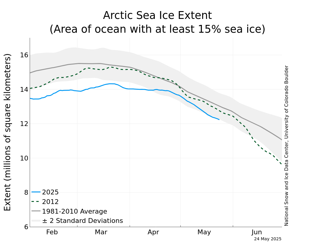
Meanwhile, the National Snow and Ice Data Center (NSIDC) has resumed daily sea ice extent updates with provisional data. The image below is dated May 5, 2016, check here for updates.

As illustrated by the image below, from JAXA, sea ice extent on May 6, 2016, was under 12 million square km, more than 15 days ahead on extent in the year 2012, which was 12 million square km on May 21, 2012.


The situation is dire and calls for comprehensive and effective action as described in the Climate Plan.

Malcolm Light comments:

Most natural processes on the Earth are run by convection including plate tectonics that moves the continental and oceanic plates across the surface of the planet. Mother Earth has been able to hold its atmospheric temperature within certain limits and maintain an ocean for more than 3 billion years because each time there was a build up of carbon dioxide in the atmosphere which produced a global fever, Mother Earth it eliminated the living creatures with a massive Arctic methane firestorm that fried them alive. This giant Arctic methane firestorm is a natural antibiotic the Earth uses to rid itself of those creatures that have overproduced carbon dioxide and caused a global fever.

Essentially mankind has again caused a massive build up of fossil fuel carbon dioxide in the atmosphere and Mother Earth has already started to respond with the predicted massive Arctic methane blow out (since 2010) which will lead to an Earth engulfing firestorm in 5 to 8 years.

The giant fires in the Fort McMurray region are a result of atmospheric methane induced heating of the Arctic and 93.5% global warming of the oceans that has generated a massive El Nino event this year. Hot winds moving away from these high pressure areas have generated high temperatures and massive fires in Alberta which is a giant fever spot on Earth where mankind has produced the maximum amount of dirty fossil fuel extraction and pollution in Canada.

Mother Earth will continue to respond more vigorously with her Arctic methane antibiotic to eliminate the humans from her system as we represent nothing more to her than a larger version of an influenza virus which has seriously retarded her oceanic and atmospheric temperature range functioning systems.

If we do not immediately stop fossil fuel extraction worldwide and control the Arctic methane emission sites we will all be stardust before a decade is past.

Links

• The Threat of Wildfires in the North
http://arctic-news.blogspot.com/2013/06/the-threat-of-wildfires-in-the-north.html

• Smoke Blankets North America