On the image below, cyclonic winds on December 21, 2017, are visible near the Philippines and Vietnam. Near the Philippines, 3-hour precipitation accumulation was as high as 121.6 mm or 4.79 in (at green circle). As a BBC report describes, Tropical Storm Tembin made landfall in the southern Philippines on December 22, 2017, causing flash flooding and mudslides. More than 180 people are reported to have been killed, as the tropical storm swept through Mindanao island, with dozens more missing.
A week earlier, Tropical Storm Kai-Tak hit the central Philippines, killing dozens. The region is still recovering from Typhoon Haiyan, which killed more than 5,000 people and affected millions in 2013.
The winds are fueled by high sea surface temperatures. Above image shows that, on December 21, 2017, sea surface temperatures were as high as 31.7°C or 89°F north of Australia. In line with rising temperatures caused by global warming, sea surface temperature anomalies are high across the oceans, as the image below illustrates.
 As above image also shows, the sea surface was relatively cold at locations indicative for El Niño (depicted as four El Niño regions on the right).
The image below shows El Niño forecast plumes indicating that we're currently in a La Niña period, and that temperatures are on the rise.
In conclusion, just like the rise in temperatures is currently masked by a La Niña period, the return to a new El Niño period will further strengthen the rise.
This strengthening of winds is what can be expected in a warmer world. Above image shows a wavy Northern Polar Jet Stream combine with the Northern Subtropical Jet Stream to reach speeds as high as 401 km/h or 249 mph.
As the jet stream becomes more wavy and extends over the Arctic, more warm air and water gets carried into the Arctic, further speeding up warming, as also discussed at The Arctic is changing the Jet Stream - Why This Is Important.
The importance of Arctic warming was also discussed in the recent post Warming is accelerating. Changes to the Jet Stream can cause a lot more heat to be brought into the Arctic, through both the Bering Strait and the Fram Strait. This image below shows wind through the Bering Strait reaching speeds as high as 135 km/h or 84 mph.
The combination image below shows the Jet Stream extending over the Arctic Ocean and remaining in place for days, reaching speeds as high as 206 km/h or 128 mph. Such 'blocking' patterns can cause a lot of heat to be brought into the Arctic atmosphere, as well as into the water of the Arctic Ocean. The image in the left-hand panel indicates that temperature anomalies over the Arctic Ocean could be as high as 30°C or 54°F.
 |
| [ click on images to enlarge ] |
As sea ice keeps declining, ever less sunlight gets reflected back into space. The image below shows the decline in global sea ice area over the years.
The image below shows the average year-to-date Arctic sea ice volume (PIOMAS data).
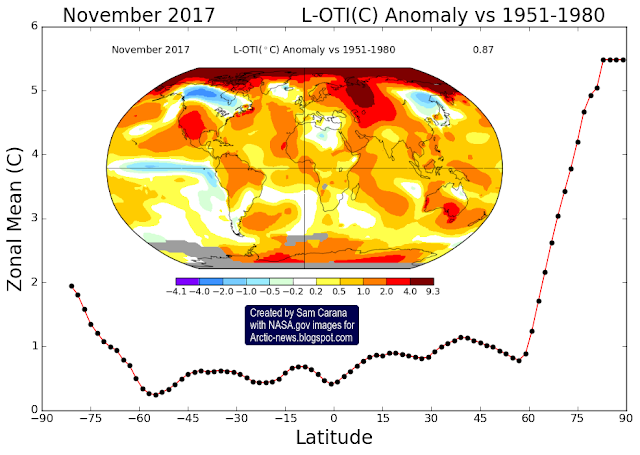
This further confirms the updated trend analysis of the NASA temperature anomaly below.
The situation is dire and calls for comprehensive and effective action, as described in the Climate Plan.
Links
• Climate Plan
https://arctic-news.blogspot.com/p/climateplan.html
• Warming is accelerating
https://arctic-news.blogspot.com/2017/11/warming-is-accelerating.html
• The Arctic is changing the Jet Stream - Why This Is Important
https://arctic-news.blogspot.com/2017/10/the-arctic-is-changing-the-jet-stream-why-this-is-important.html
• NASA: November 2017 temperature news release
https://data.giss.nasa.gov/gistemp/news/20171218
• BBC: Philippines Tropical Storm Tembin kills 180 on Mindanao
https://www.bbc.com/news/world-asia-42464644
• NOAA: Four El Niño regions
http://www.cpc.ncep.noaa.gov/products/analysis_monitoring/ensostuff/nino_regions.shtml
• ECMWF: El Niño forecast plumes
https://www.ecmwf.int/en/forecasts/charts/catalogue/seasonal_system5_public_nino_plumes
• 10°C or 18°F warmer by 2021?
https://arctic-news.blogspot.com/2017/04/10c-or-18f-warmer-by-2021.html
• Abrupt Warming - How Much And How Fast?
https://arctic-news.blogspot.com/2017/05/abrupt-warming-how-much-and-how-fast.html
• Accelerating growth in CO₂ levels in the atmosphere
https://arctic-news.blogspot.com/2017/02/accelerating-growth-in-co2-levels-in-the-atmosphere.html
• High methane levels over the Arctic Ocean on January 14, 2014
https://arctic-news.blogspot.com/2014/01/high-methane-levels-over-the-arctic-ocean-on-january-14-2014.html
• Feedbacks
https://arctic-news.blogspot.com/p/feedbacks.html
• Extinction
https://arctic-news.blogspot.com/p/extinction.html
• Methane Erupting From Arctic Ocean Seafloor
https://arctic-news.blogspot.com/2017/03/methane-erupting-from-arctic-ocean-seafloor.html
• Warning of mass extinction of species, including humans, within one decade
https://arctic-news.blogspot.com/2017/02/warning-of-mass-extinction-of-species-including-humans-within-one-decade.html


