Above image shows a forecast of air temperature of 0.2°C or 32.4°F at 1000 hPa over the North Pole on February 5, 2018, 21:00 UTC.
Above image shows a forecast of temperatures of 1.1 °C or 33.9°F at the North Pole at 1000 hPa, on February 5, 2018, 18:00 UTC.
Above image shows a large area around the North Pole forecast to be up to 30°C or 54°F warmer than 1979-2000 on February 5, 2018.
Above image shows sea surface temperatures as high as 15.1°C or 59.2°F near Svalbard on February 9, 2018, in the panel on the left, and air temperatures as high as 6°C or 42.7°F (at 1000 hPa) near Svalbard on February 10, 2018, in the panel on the right.
These high temperatures are caused not only by ocean heat, but also by strong winds pushing warm air and water up from the North Atlantic into the Arctic. Above image shows the Jet Stream moving at speeds as high as 315 km/h or 196 mph (green circle, February 6, 2018, 6:00 UTC), moving in backward direction over Scandinavia, while extending over Antarctica and crossing the Equator at a number of places.
The decreasing temperature difference between the North Pole and the Equator is slowing down the speed at which the jet stream circumnavigates Earth and this is also making the jet stream more wavy.
As a more wavy jet stream extends deeper down over land, it allows cold air from the Arctic to flow down over land. As temperatures over land fall, the difference between ocean temperature and land temperature increases, especially in winter when land temperatures are much lower than ocean temperatures. This increasing difference between land and ocean temperature makes winds stronger and faster over oceans.
 |
| [ click on images to enlarge ] |
In above image, the right panel shows strong winds pushing warm air from the Pacific Ocean through Bering Strait, resulting in temperatures over Alaska as high as 6.6°C or 44°F (at green circle, at 850 hPa).
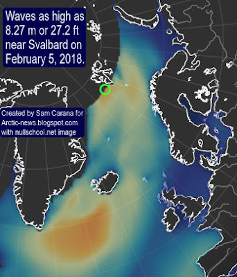
The image on the right shows that waves as high as 8.27 m or 27.2 ft (at green circle) are forecast to enter the Arctic Ocean near Svalbard on February 5, 2018, giving an indication of the huge amount of energy that is going into oceans.
 Earth is retaining more heat. This translates into higher surface temperatures, more heat getting stored in oceans and stronger winds. This in turn is causing higher waves and more evaporation from the sea surface. The image on the right shows a forecast of total amount of cloud water (in air from surface to space) of 1.5 kg/m² (green circle) in between Svalbard and the North Pole on February 5, 2018.
The high temperatures at the North Pole follow high temperatures over East Siberia, as illustrated by the image below.
Above image shows average temperature anomalies for January 31, 2018, compared to 1979-2000. The image below shows open water on the East Siberian coast in the Arctic Ocean that day.
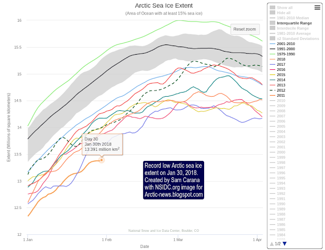
Meanwhile, Arctic sea ice extent is very low. The image below shows that extent on January 30, 2018, was 13.391 million km², a record low for the time of the year.
In the video below, Paul Beckwith discusses the situation.
|
The image below shows that on February 11, 2018, methane reached peak levels as high as 2925 ppb.
High methane peaks are becoming more common as the water temperature of oceans keeps rising, which also goes hand in hand with more water vapor and less sea ice. As said, these are all warming elements that amplify each other in many ways.
 On Feb 8, 2018, Antarctic sea ice extent was 2.382 million km², a record low for the time of the year and 1.811 million km² less than the extent on Feb 8, 2014.
 The image on the right illustrates the huge loss of sea ice around Antarctica over the past few years. Antarctic sea ice looks set to reach an all-time low extent later this month, with a difference of close to 2 million km² persisting, compared to just a few years ago.
The image below shows a forecast for February 5, 2018, with as much as 3.84 kg/m² (green circle) Total Cloud Water in between South Africa and Antarctica.
More water vapor in the air contributes to global warming, since water vapor is a potent greenhouse gas. The image below shows a forecast for February 5, 2018, with temperatures on Antarctica reaching as high as 8.9°C or 47.9°F (update Feb. 11, 2018: 7.1°C or 44.7°F at 78°S, 17°E at 1000 hPa on Feb. 5, 2018, 15:00z).
At this time of year, global sea ice is typically at its lowest extent for the year. On February 9, 2018, global sea ice reached the lowest extent on record, as illustrated by the image below by Wipneus.
This means that a huge amount of sunlight that was previously reflected back into space is now instead getting absorbed by oceans.
The situation is dire and calls for comprehensive and effective action, as described in the Climate Plan.


