Tampilkan postingan dengan label rise. Tampilkan semua postingan

Warning Signs


The Arctic is warming up more than twice as fast as the rest of the world, due to numerous feedbacks. At times, large areas over the Arctic Ocean can become 30°C or 54°F warmer than 1979-2000, as illustrated by the image below.


On February 27, 2018, large parts of the Arctic Ocean north of Greenland had turned into open water, as illustrated by the image below.


Yet, while the situation in the Arctic is desperate, with sea ice north of Greenland collapsing and more, mainstream media do not seem to care. If there ever were warning signs of what could eventuate, this is one. The sea ice north of Greenland is typically the thickest, as it is the least affected by melting and can build over many years. Early February 2018, sea ice north of Greenland was up to 5 m thick. To see sea ice this thick getting pushed away and open water emerging north of Greenland in the middle of winter is simply stunning.

For years, I've been warning about the situation in the Arctic, in particular the 'Open Doors Feedback', which is accelerating Arctic warming. Such feedbacks were taken into consideration in an earlier analysis that warned about a potential 1.6°C warming globally due to albedo changes in the Arctic, in combination with associated changes such as loss of the ice buffer (latent heat), more heat transfer from the Atlantic Ocean to the Arctic Ocean due to stronger winds along the path of the Gulf Stream, and more heat entering the atmosphere or remaining in the atmosphere, due to more open water in the Arctic Ocean and as oceans get more stratified and take up less heat from the atmosphere.

So, the current situation doesn't come as a big surprise, but it's stunning to see sea ice collapse north of Greenland.

Back in March 7, 2007, I posted the article 'Ten Dangers of Global Warming', describing events getting progressively worse, with one danger feeding and reinforcing the next one, culminating in panic. Then, I thought that reading that post could at least help people better understand what's going on, and thus help people avoid panicking, but right now, I wonder whether most people do want to understand at all. Anyway, here are some images and words describing what happened over the past few days.

Jet Stream over Arctic Ocean on February 25, 2018

As Arctic warming keeps accelerating, there's ever less temperature difference between the North Pole and the Equator, and this slows down the speed at which the jet stream circumnavigates Earth.

Jet Stream over Arctic Ocean on February 26, 2018
The jet stream is getting more wavy and a more wavy jet stream makes it easier for cold air to move out of the Arctic and for warm air to move into the Arctic, so this 'Open Doors Feedback' is a self-reinforcing feedback that further accelerates warming in the Arctic.

During the northern winter, the Arctic is increasingly getting warmer than North America, Europe and Siberia. This increases the temperature difference between these continents and the oceans, which at times is causing winds to strongly speed up over the North Atlantic and the North Pacific, making an already wavy jet stream extend even further over the Arctic Ocean, reaching areas well beyond the North Pole.

Atmospheric river of heat reaches the North Pole; temperatures were as high as 1.1°C or 34.1°F on February 25, 2018

As the jet stream makes this detour, a huge amount of heat enters the Arctic from the south.

Temperatures above 6°C at Kap Morris Jesup, Greenland's northernmost weather station, on February 25, 2018

These events were preceded by the Polar Vortex splitting up. On February 9, 2018, the Polar Vortex was split up into 4 vortices and reached speeds as fast as 425 km/h or 264 mph.

Polar Vortex split up into 4 vortices

A Sudden Stratospheric Warming event occurred on February 16, 2018, with temperatures reaching as high as 8.9°C or 47.9°F over Hudson Bay.

Polar Vortex splitting up into 4 vortices with a Sudden Stratospheric Warming event occurring on February 16, 2018


The image below is an animation of sea ice thickness, from the Naval Research Laboratory.


Arctic sea ice extent was at record low for the time of the year on February 26, 2018, at 14.159 million km². Arctic sea ice extent typically reaches its maximum in March, but maximum extent in 1991-2000 was reached on February 24. So, there is a chance that Arctic sea ice extent will go all downhill from now on this year.


Zero sea ice volume is within the margins of the trend depicted on the image above on the right. Disappearance of the sea ice also means loss of the buffer that until now has consumed huge amounts of heat. 

The Buffer has gone, feedback #14 on the Feedbacks page
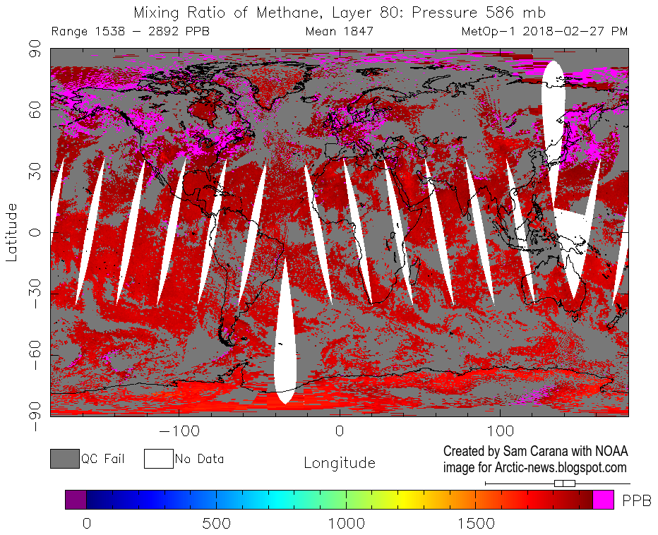
Here's another warning sign. High methane releases followed this chain of events on February 27, 2018, pm, likely originating from the seafloor of the East Siberian Arctic Shelf (ESAS).
Methane levels as high as 2892 ppb on February 27, 2018
Add up the impact of all warming elements and, as an earlier analysis shows, the rise in mean global temperatures from preindustrial could be more than 10°C in a matter of years, as illustrated by the images below.


A 2°C rise in temperature alone is devastating, especially when considering that the speed at which this rise could occur leaves little or no time for plants and animals to adapt.


The situation is dire and calls for comprehensive and effective action, as described in the Climate Plan.

Links

• Climate Plan
https://arctic-news.blogspot.com/p/climateplan.html

• Feedbacks in the Arctic
https://arctic-news.blogspot.com/p/feedbacks.html

• Extinction
https://arctic-news.blogspot.com/p/extinction.html

• Ten Dangers of Global Warming
https://arctic-news.blogspot.com/p/ten-dangers-of-global-warming.html


IPCC seeks to downplay global warming

The graph below shows global warming for a 30-year period centered on January 2018, using NASA 2003 to January 2018 LOTI anomalies from 1951-1980, adjusted by 0.59°C to cater for the rise from preindustrial to 1951-1980, and with a polynomial trend added.


From: ECMWF Nino Plumes
Above graph shows that the 1.5°C guardrail, set at the Paris Agreement, was crossed in 2016 and that a 10°C (18°F) warming could eventuate within a decade or so.

The variations in above temperature data are strongly influenced by El Niño/La Niña. We currently are in a La Niña period, during which surface temperatures are suppressed, whereas surface temperatures in 2016 were much above the trendline, due to El Niño.

The ECMWF forecast from 1 February 2018 on the right indicates that we're heading for another El Niño, i.e. surface temperatures will be rising strongly over the coming months.

The IPCC seeks to downplay the amount of global warming that has already occurred and that looks set to eventuate over the next decade or so. A leaked draft of the IPCC 'Special Report on 1.5°C above pre-industrial' (First Order Draft of SR1.5 SPM) estimates that the global mean temperature reached approximately 1°C above pre-industrial levels around 2017/2018. The IPCC appears to have arrived at this estimate using an extrapolation or near term predictions of future warming so that the level of anthropogenic warming is reported for a 30 year period centered on today.

This 1°C IPCC estimate looks quite incredible when calculating the temperature rise using NASA's data for the two most recent years for which data are available (2016/2017), which shows a warming of 0.95°C when using a baseline of 1951-1980 and a warming of 1.23°C when using a baseline of 1890-1910.


Indeed, the temperature rise differs depending on which baseline is used, and when using preindustrial as a baseline, i.e. the baseline agreed to at the Paris Agreement, indications are that temperatures have already risen by more than 1.5°C, as also discussed in an earlier post.

Furthermore, when using a 30-year period centered on January 2018, the current temperature will have to be calculated over the past 15 years and estimated for the next 15 years, i.e. up to the year 2033.

To arrive at a 1°C rise for the 30-year period, the IPCC must somehow assume that temperatures will magically fall dramatically over the next 15 years, whereas indications are that temperatures will instead rise dramatically over the next decade or so.

The image on the right shows that 10°C (18°F) warming from preindustrial could eventuate within one decade when taking into full account the warming that could result from the elements depicted in the stacked bar. Each of these warming elements is discussed in more detail at the extinction page.

The image below shows the rise from 1750 to 2030, in surface temperatures (land+ocean), rather than in anomalies.


The situation is dire and calls for comprehensive and effective action, as described in the Climate Plan.


North Pole forecast to be above freezing on Feb 5, 2018

The image below shows a forecast of above freezing temperatures over the North Pole on Feb 5, 2018.


Above image shows a forecast of air temperature of 0.2°C or 32.4°F at 1000 hPa over the North Pole on February 5, 2018, 21:00 UTC.


Above image shows a forecast of temperatures of 1.1 °C or 33.9°F at the North Pole at 1000 hPa, on February 5, 2018, 18:00 UTC.


Above image shows a large area around the North Pole forecast to be up to 30°C or 54°F warmer than 1979-2000 on February 5, 2018.


Above image shows sea surface temperatures as high as 15.1°C or 59.2°F near Svalbard on February 9, 2018, in the panel on the left, and air temperatures as high as 6°C or 42.7°F (at 1000 hPa) near Svalbard on February 10, 2018, in the panel on the right.


These high temperatures are caused not only by ocean heat, but also by strong winds pushing warm air and water up from the North Atlantic into the Arctic. Above image shows the Jet Stream moving at speeds as high as 315 km/h or 196 mph (green circle, February 6, 2018, 6:00 UTC), moving in backward direction over Scandinavia, while extending over Antarctica and crossing the Equator at a number of places.


The decreasing temperature difference between the North Pole and the Equator is slowing down the speed at which the jet stream circumnavigates Earth and this is also making the jet stream more wavy.

As a more wavy jet stream extends deeper down over land, it allows cold air from the Arctic to flow down over land. As temperatures over land fall, the difference between ocean temperature and land temperature increases, especially in winter when land temperatures are much lower than ocean temperatures. This increasing difference between land and ocean temperature makes winds stronger and faster over oceans.

[ click on images to enlarge ]
In above image, the left panel shows a wavy jet stream speeding up over the North Atlantic, reaching speeds as high as 345 km/h or 215 mph (at green circle, 250 hPa).

In above image, the right panel shows strong winds pushing warm air from the Pacific Ocean through Bering Strait, resulting in temperatures over Alaska as high as 6.6°C or 44°F (at green circle, at 850 hPa).

The image on the right shows that waves as high as 8.27 m or 27.2 ft (at green circle) are forecast to enter the Arctic Ocean near Svalbard on February 5, 2018, giving an indication of the huge amount of energy that is going into oceans.

Earth is retaining more heat. This translates into higher surface temperatures, more heat getting stored in oceans and stronger winds. This in turn is causing higher waves and more evaporation from the sea surface. The image on the right shows a forecast of total amount of cloud water (in air from surface to space) of 1.5 kg/m² (green circle) in between Svalbard and the North Pole on February 5, 2018.

Warm air, warm water and high waves make it hard for sea ice to form, while evaporation from the ocean adds more water vapor to the atmosphere. Since water vapor is a potent greenhouse gas, this further accelerates warming of the Arctic.

The high temperatures at the North Pole follow high temperatures over East Siberia, as illustrated by the image below.


Above image shows average temperature anomalies for January 31, 2018, compared to 1979-2000. The image below shows open water on the East Siberian coast in the Arctic Ocean that day.


Meanwhile, Arctic sea ice extent is very low. The image below shows that extent on January 30, 2018, was 13.391 million km², a record low for the time of the year.


In the video below, Paul Beckwith discusses the situation.


In the podcast below, by Wolfgang Werminghausen, entitled Sam Carana about the Arctic and global temperature, Sam Carana's responses are read by Kevin Hester.

From the interview, Sam Carana: "Methane releases from the seafloor of the Arctic Ocean have a strong warming impact, especially locally, AND methane releases in the Arctic also act as a catalyst for other feedbacks that are all self-reinforcing and interlinked, amplifying each other in many ways. It could easily become 10°C or 18°F warmer in a matter of years, especially in places where most people are now living."


The image below shows that on February 11, 2018, methane reached peak levels as high as 2925 ppb.

High methane peaks are becoming more common as the water temperature of oceans keeps rising, which also goes hand in hand with more water vapor and less sea ice. As said, these are all warming elements that amplify each other in many ways.

On Feb 8, 2018, Antarctic sea ice extent was 2.382 million km², a record low for the time of the year and 1.811 million km² less than the extent on Feb 8, 2014.

The image on the right illustrates the huge loss of sea ice around Antarctica over the past few years. Antarctic sea ice looks set to reach an all-time low extent later this month, with a difference of close to 2 million km² persisting, compared to just a few years ago.

The image below shows a forecast for February 5, 2018, with as much as 3.84 kg/m² (green circle) Total Cloud Water in between South Africa and Antarctica.


More water vapor in the air contributes to global warming, since water vapor is a potent greenhouse gas. The image below shows a forecast for February 5, 2018, with temperatures on Antarctica reaching as high as 8.9°C or 47.9°F (update Feb. 11, 2018: 7.1°C or 44.7°F at 78°S, 17°E at 1000 hPa on Feb. 5, 2018, 15:00z).


At this time of year, global sea ice is typically at its lowest extent for the year. On February 9, 2018, global sea ice reached the lowest extent on record, as illustrated by the image below by Wipneus.


This means that a huge amount of sunlight that was previously reflected back into space is now instead getting absorbed by oceans.

The situation is dire and calls for comprehensive and effective action, as described in the Climate Plan.


2017 was hottest year on record

The year 2017 was the hottest year on record, as the image below illustrates.


When determining which year was the hottest year, care should be taken to avoid bias due to temporary conditions such as the El Niño that was present in 2016 and the La Niña we're now experiencing now. Above image uses NASA land+ocean January 2012-December 2017 anomalies from 1951-1980, adjusted by 0.59°C to cater for the rise from preindustrial to 1951-1980, to calculate a linear trend that goes some way to smooth out variability due to El Niño/La Niña events. The trend shows that 2017 was significantly warmer than 2016.

The trend also shows that 1.5°C above preindustrial was crossed back in 2016. This 1.5°C (or 2.7°F) was set at the Paris Agreement as a guardrail that was not to be crossed. The trend further shows that we've meanwhile crossed 1.6°C above preindustrial and we look set to cross the 2°C guardrail within years.


Global warming has crossed 1.5°C / 2.7°F above preindustrial and looks set to cross 2°C / 3.6°F soon. Due to accelerating warming in the Arctic, that could happen within one or two years time, i.e. much faster than the trendlines below may suggest.


Indeed, warming in the Arctic is taking place much faster than elsewhere, and the difference is accelerating. There's a huge danger that accelerating warming in the Arctic will speed up feedbacks such as:
• huge amounts of methane getting released from the seafloor of the Arctic Ocean;
• melting of sea ice and permafrost causing more sunlight to get absorbed in the Arctic, as less sunlight gets reflected back into space;
• changes to jet streams causing more extreme weather, in turn resulting in more emissions, such as due to wildfires;
• and more.

In conclusion, feedbacks could speed up global warming by much more than what may be suggested by above trends that look only at surface temperature of the atmosphere and that are based on previous data when such feedbacks had yet to become manifest.

Add up the impact of all warming elements and, as an earlier analysis shows, the rise in mean global temperatures from preindustrial could be more than 10°C in a matter of years, as illustrated by the image below, which shows a much steeper rise.


Particularly devastating feedbacks could result from changes regarding heat and carbon dioxide taken up by oceans. Oceans now take up 93.4% of global warming, as illustrated by the image below.


As said, when looking at surface temperatures of the atmosphere, there will be bias due to El Niño/La Niña events. One way to smooth out such bias is by calculating trendlines over many years. Another way to compensate for such bias is to also look at ocean heat. In terms of ocean heat, the year 2017 stands at the top, as the left panel of above image illustrates. In 2016, El Niño caused relatively more heat to be present in the atmosphere and less in oceans, whereas the opposite occurred in 2017, contributing to the fact that in 2017 a record amount of ocean heat was recorded. Occurrence of El Niño/La Niña events over the years is visualized by the image below.


One danger is that, in future, there will be more impact by El Niño events and less by La Niña events. A recent study concludes that as temperatures rise due to emissions by people, the frequency, magnitude and duration of strong El Niño events will increase.

In addition to higher temperature peaks due to El Niño events, more heat could remain in the atmosphere as the rise in temperature in general causes greater ocean stratification, making that less heat gets absorbed by oceans, as discussed in several earlier posts. The image below depicts this feedback and further feedbacks mentioned above. Feedbacks are described in more detail at the feedbacks page.


The situation is further illustrated by the danger assessment below.

[ Danger Assessment, from earlier post ]
Meanwhile, the Global Carbon Project projects a growth of 2% for the 2017 global carbon dioxide emissions from fossil fuels and industry (including cement production), compared to 2016 levels, as illustrated by image below.  

The situation is dire and calls for comprehensive and effective action as described in the Climate Plan.


Links

• Climate Plan
https://arctic-news.blogspot.com/p/climateplan.html

• Warming is accelerating
https://arctic-news.blogspot.com/2017/11/warming-is-accelerating.html

• The Arctic is changing the Jet Stream - Why This Is Important
https://arctic-news.blogspot.com/2017/10/the-arctic-is-changing-the-jet-stream-why-this-is-important.html

• 10°C or 18°F warmer by 2021?
https://arctic-news.blogspot.com/2017/04/10c-or-18f-warmer-by-2021.html

• Abrupt Warming - How Much And How Fast?
https://arctic-news.blogspot.com/2017/05/abrupt-warming-how-much-and-how-fast.html

• Feedbacks
https://arctic-news.blogspot.com/p/feedbacks.html

• Extinction
https://arctic-news.blogspot.com/p/extinction.html

• Methane Erupting From Arctic Ocean Seafloor
https://arctic-news.blogspot.com/2017/03/methane-erupting-from-arctic-ocean-seafloor.html

• Warning of mass extinction of species, including humans, within one decade
https://arctic-news.blogspot.com/2017/02/warning-of-mass-extinction-of-species-including-humans-within-one-decade.html


Unfolding Arctic Catastrophe

On January 1, 2018, methane levels as high as 2764 ppb (parts per billion) were recorded. The solid magenta-colored areas near Greenland indicate that this very high reading was likely caused by methane hydrate destabilization in the sediments on the seafloor of the Arctic Ocean.


The state of the sea ice is behind this. On January 1, 2018, Arctic sea ice extent was at record low for the time of the year. The smaller the extent, the less sunlight gets reflected back into space and is instead absorbed in the Arctic.

At this time of year, though, hardly any sunshine is reaching the Arctic. So, what triggered this destabilization? As the image below indicates, year-to-date average Arctic sea ice volume has been at record low in 2017, which means that there has been very little sea ice underneath the surface throughout 2017.


Warm water will melt the sea ice from below, which keeps the water at greater depth cool. However, when there is little or no sea ice underneath the surface, little or no heat will be absorbed by the process of melting and the heat instead stays in the water, with the danger that it will reach sediments at the bottom of the Arctic Ocean, as illustrated by the image below.

The Buffer has gone, feedback #14 on the Feedbacks page
[ image from: Warming is accelerating ]
The image on the right shows warm water from the North Atlantic arriving near Svalbard. How warm is the water beneath the surface of the Arctic Ocean? The image below gives an indication, showing how much warmer the water was from October 1, 2017, to December 30, 2017, at selected areas near Svalbard, where warm water from the North Atlantic dives under the sea ice of the Arctic Ocean, carried by the Gulf Stream.

[ click on images to enlarge ]
In 1981-2011, temperatures were gradually falling by more than one degree Celsius from October 1 to the December 21 Solstice, then started to rise again in line with the change in seasons (blue line). In 2017, temperatures were rising in October. On October 25, 2017, the sea surface was as warm as 17.5°C or 63.5°F, i.e. a 14.1°C or 24.5°F anomaly. On average, it was 12.96°C or 23.35°F warmer during the period from October 1 to December 30, 2017 (red line), compared to the same days in 1981-2011.

The images below further illustrate the situation. Surface temperature of the atmosphere near Svalbard was as warm as 7°C or 44.5°F on January 13, 2018 (at green circle, left panel). The sea surface near Svalbard was as warm as 15.9°C or 60.8°F on January 12, 2018, compared to 2.4°C or 36.4°F on January 12 for the period 1981-2011 (at green circle, center panel). Waves as high as 13.04 m or 42.8 ft (at green circle, right panel) batter the North Atlantic along Norway's coast all the way to Svalbard on January 15, 2018.


The image below shows that waves as high as 16.01 m or 52.5 ft are forecast to batter the North Atlantic on January 16, 2018 (green circle, left panel). 100% relative humidity is recorded over the Arctic Ocean on January 15, 2018 (green circle, center panel). The Jet Stream reaches speeds as high as 426 km/h or 264 mph on January 15, 2018 (green circle, right panel).


Similar extreme weather patterns can be seen elsewhere in the Arctic. The image below on the left shows that temperatures as high as 18.5°C or 65.3°F were recorded on Jan. 14 and 15, 2018 in Metlakatla, Alaska. The image below on the right shows that surface temperatures as high as 7.4°C or 45.2°F were reached on January 16, 2018, in Yukon Territory, Canada (at green circle).

[ click on images to enlarge ]

In conclusion, as the Arctic is warming up faster than the rest of the world, Jet Streams are getting more wavy, resulting in more extreme weather events. Wind speed accelerates over warmer oceans, pushing more heat into the Arctic Ocean, threatening to cause eruptions of huge amounts of methane from the Arctic Ocean seafloor.

The situation is dire and calls for comprehensive and effective action as described at the Climate Plan.


Links

• Climate Plan
https://arctic-news.blogspot.com/p/climateplan.html

• Warming is accelerating
https://arctic-news.blogspot.com/2017/11/warming-is-accelerating.html

• Feedbacks
https://arctic-news.blogspot.com/p/feedbacks.html

• 10°C or 18°F warmer by 2021?
https://arctic-news.blogspot.com/2017/04/10c-or-18f-warmer-by-2021.html

• Abrupt Warming - How Much And How Fast?
https://arctic-news.blogspot.com/2017/05/abrupt-warming-how-much-and-how-fast.html

• Accelerating growth in CO₂ levels in the atmosphere
https://arctic-news.blogspot.com/2017/02/accelerating-growth-in-co2-levels-in-the-atmosphere.html

• High methane levels over the Arctic Ocean on January 14, 2014
https://arctic-news.blogspot.com/2014/01/high-methane-levels-over-the-arctic-ocean-on-january-14-2014.html

• Extinction
https://arctic-news.blogspot.com/p/extinction.html

• Methane Erupting From Arctic Ocean Seafloor
https://arctic-news.blogspot.com/2017/03/methane-erupting-from-arctic-ocean-seafloor.html

• 2015 warmest year on record
https://arctic-news.blogspot.com/2015/12/2015-warmest-year-on-record.html

• Accelerating Warming of the Arctic Ocean
https://arctic-news.blogspot.com/2016/12/accelerating-warming-of-the-arctic-ocean.html

• Arctic Ocean Feedbacks
https://arctic-news.blogspot.com/2017/01/arctic-ocean-feedbacks.html

• Warning of mass extinction of species, including humans, within one decade
https://arctic-news.blogspot.com/2017/02/warning-of-mass-extinction-of-species-including-humans-within-one-decade.html